NEW ULM IS ON NATIONAL ROADS ROUTE THRU U.S.
Systems Were Mapped Out At The Session
Held In Washington.
——–
MARKING HIGHWAYS TO AID TRAFFIC
——–
Trunk Lines From
North To South Border Run Thru Minnesota.
———-
New Ulm is on the route of one of the newly selected United States highways, according to word received from Washington D.C., where a joint interstate highway board chose 50,000 miles of roadway extending over the length and breadth of the country, to be designated by uniform road markets.
No thru routes are provided by the system which embraces all state capital and as many points of national and sectional interest as it was possible to include. All Federal aid highways are included.
The national road, which connects New Ulm and surrounding territory with the national system, enters the state at Lake Benton on the western boundary, proceeds to Sanborn, New Ulm, Mankato, and on to Owatonna, and Winona before entering Wisconsin. The route of trunk highway No. 7 is practically duplicated.
The routes will be numbered and marked with uniform signs and curves and railroad crossings.
An index of location and route for American tourists in virtually every section and by way of the country will be afforded in the marking of the vast system of United States highways, as selected by the joint board of interstate highways.
A network of roads stretching from the Atlantic to the Pacific, and from the Canadian border to the Gulf is embraced in the 50,000 miles of highways to be designated with uniform markers to tell the motorist exactly what road he is on and where it will take him:
Grouping Left To Committee.
In carrying its work to this point, the joint board has left to a subcommittee the actual grouping of the selected roads into main arterial highways the sub-committee in making tentative designations to be submitted to the various states for approval will carry out the purpose of bringing within the system all the nation’s larger cities, state capitals and resorts and points of general interest.
Designations of the system, which includes every federal aid highway in the United States, involves no new road construction other than roads now planned under the federal aid programs.
Minnesota Marked Roads.
Minnesota: One road runs from Grand Forks(N. D.) to Crookston, Bagley, Bemidji, Grand Rapids, and Duluth. Another runs from Moorhead to Detroit. Wadena, Staples, Brainerd, Kimberly and Duluth. Another goes from Ortonville to Benson, Willmar, Litchfield, and Minneapolis, and from Lake Benton to Sanborn, New Ulm, Mankato, Owatonna, thence into Wisconsin via Winona. Another from Luverne to Jackson, Albert Lea, Austin, Preston, thence into Wisconsin at LaCrosse, and another from International Falls on the Canadian border to Bemidji, Sanborn and Jackson. Another from Wadena to Staples, St. Cloud and Minneapolis. Another from Duluth to Pine City. Minneapolis, Owatonna and Austin.
North Dakota Group.
North Dakota routes designated are: Williston to Crosby to Canadian border; From Williston, Stanley,Minot to Winner, Devils Lake, Grand Forks, Hillsboro, thence along the Minnesota border to Fargo, toward Sisseton, S.D., from Fargo, Jamestown, Bismarck, Dickinson, Medora to Beach; from Williston, Medora, Bowman to South Dakota border; from Bowman, Hettinger along South Dakota border to MaeIntosh, thence into South Dakota.
New Ulm Review,
Aug. 12, 1925
————————
History
BOWLING ACTIVITY SOON TO COMMENCE
Four Special Teams to Be Organized to Take Part in Tournaments. Other Teams Also. ———— “CY” ...
LAKE SHETEK DREW BIG CROWD SUNDAY
Dedication Exercises Of Memorial Monument On Historical Site. ———— Twenty thousand persons attended the ...
Residents would rather switch, get sidewalks
Residents of N. Franklin from 12th to 14th N. pulled a switch Tuesday and asked the New Ulm City Council to allow ...
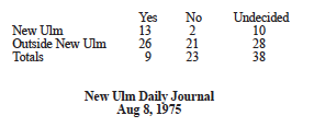
The Nixon resignation: Citizens reflect on its effect
NEW ULM IS ON NATIONAL ROADS ROUTE THRU U.S.
Systems Were Mapped Out At The Session Held In Washington. ———— MARKING HIGHWAYS TO AID ...